The Kisbey Sub once ran from Arcola (mile 0.0) to Weyburn (mile 61.8), Saskatchewan via Griffin, and Stoughton. In Weyburn, it had a junction with the Weyburn Sub; at Griffin it crossed CN's former Lewvan Sub, at Stoughton a junction with the Tyvan Sub, and at Arcola it became the Arcola Sub to the east.
 |
| Google Screen shot of the Kisbey Sub. Started at Weyburn, ended at Arcola. |
According to the info I could find, this sub was abandoned in steps, and as permitted by the Canadian Transportation Agency (CTA). The first section was to be abandoned was from mile 43.6 near Griffin to mile 60.9 just outside Weyburn in 1989 (Order No. 1989-R-370). This was followed by miles 0.5 near Arcola to 23.3 south of Stoughton in 1990 (Order No. 1990-R-126). In 1993, the CTA gave CP permission to remove the rails between Stoughton, and Griffin (Order No. 1993-R391), leaving only what is left today.
In mid July, I made a trip to Moose Mountain Provincial Park. The route to the park follows the old Kisbey Sub right of way for most of the trip, so I took some pictures along the way. I do need to apologize for the quality of the pictures in this post though. At the time, I couldn't find my camera charger, so the cell phone took its place. The charger has been found since.
 |
| Looking west towards the Weyburn Sub in Weyburn. |
 |
| Looking east towards Nexans in Weyburn. |
As you can see in the above pictures, the spur in Weyburn doesn't get used often. Usually Nexans only has two tor three cars at a time, if that.
Following the sub east, the next point of interest is near Griffin. Here, the Kisbey Sub crossed CN's Lewvan Sub. The Lewvan was pulled up a number of years ago, but recent enough that I could walk up to the old junction just off the highway and grab some pictures (I'll be doing another post on this sub in the future).
 |
| Kisbey Sub looking west at Griffin. |
 |
| Kisbey Sub looking east at Griffin |
 |
| Lewvan Sub looking south at Griffin |
 |
| Lewvan Sub looking north, including the Kisbey Sub junction |
The next stop was Stoughton, where there are a few points of interest.
First, is the former junction with the Tyvan Sub, where there once was a wye. Today however, the Stewart Southern Railway uses only a small portion in the south leg to park its older power, as seen below. This is the west end of track in Stoughton.
There is rail under all that grass/weeds.
 |
| SSR power parked at Stoughton (looking east) |
 |
| Looking west at Stoughton. |
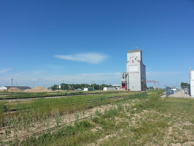
Through Stoughton, where the track turns south-east for a short distance, the rail remains in place to service a grain elevator in town. This elevator was once a Saskatchewan Pool elevator.
 |
| Tracks still in place south of the junction |
Continuing south-east for less than a mile, we come to the other end of track in Stoughton. Here we see a former Pioneer Grain Elevator. This elevator, unlike the previous, is now unused and acts as car storage area. The elevator is slated to be torn down due to a contract obligation, but according to this article, locals are fighting to save it! The article also gives a brief history on the elevator, and the materials used to build it.
For those wondering, yes those are empty oil cars.
 |
| Cars stored south of Stoughton at the former Pioneer Elevator. You can see the former Pool elevator in the distance |
Looking south from the same location is a lot less exciting, as there are no tracks in place any more. Not sure if that business on the left was ever served by rail. Almost looks like too new of a facility.
 |
| Looking south at Highway 13 crossing |
This brings us to the last stop on the Kisbey Sub, Arcola. This was once the location of mile 0.0, and marked the junction with the Arcola Sub. Today however, neither of those subs reach this small town. All that remains is the elevator they once served.
 |
| Looking east at Arcola towards. The elevator seen here was also a former Saskatchewan Pool Elevator. |
The remnants of the Kisbey Sub to the west are not so obvious here. I believe that the ROW once ran to the left of the trees, and under that trailer in the picture below.
 |
| Looking west at Arcola |
That marks the end of this segment of Abandoned Rails, but there are more to come in the future.
Extra Content
As I continued the trip east before turning north to Moose Mountain, I made a stop in Carlyle and took a few pictures of the Lampman Sub. Below, you can see that the signals for the old junction between CN's Lampman Sub, and CP's Arcola Sub are still in place, despite that fact the the Arcola Sub no longer runs through here.
 |
| Lampman Sub in Carlyle |


Nice work documenting the former sub!
ReplyDeleteThanks you, sir
DeleteThat's some serious rail archeology. Fascinating stuff.
ReplyDeleteThanks for reading Michael
DeleteThanks for reading Michael
DeleteHi David,
ReplyDeleteI just found your blog. You've got some great content on here. Wish I would have found it sooner. :)
I've noticed that you usually have some good rail maps, where do you generate those from?
DaveM
Thanks, Dave!
DeleteThe rail maps I use are all self made on Google Maps. I have the majority of active Canadian railways done, and a good chunk of the U.S. I'll likely be doing a blog post on this in the near future, and making it available to others.
Thanks again,
David-G
This comment has been removed by the author.
ReplyDelete